

Mount Mælifell, one of the most beautiful and iconic mountains in Iceland
Certain places look so impeccable that they don’t seem real. Natural elements shaped by the forces of the Earth in such a perfect way that one may think they are artificial. Like part of a movie set.
A few monuments in Iceland fit perfectly into this category. And not many look so surreal as Mount Mælifell, one of the country’s most distinctive natural landmarks. It’s a cone-shaped volcano covered in green moss rising from a vast black sand plain in the southern Highlands. Visitors are often left speechless by Mælifell, which creates a sharp contrast against the surrounding volcanic desert.
This remote site, part of the Fjallabak Nature Reserve, offers a glimpse into Iceland's raw geological forces, especially how volcanoes have shaped this land. Mount Mælifell is a remarkable geological feature, and visiting is a fantastic travel experience. On top of that, it’s in a region with a lot to see, so the trip can be combined with other sights or activities. However, it’s a bit remote, and traveling there requires some planning.
Let’s see everything there is to know about this place.
Key Information
- Mount Mælifell is a volcano located in the Icelandic Highlands.
- It has a perfect conical shape and it’s covered in green moss.
- It’s one of the most photographed mountains in Iceland.
What is Mount Mælifell?
Mount Mælifell is a 791-meter (2,595-foot) tall composite cone volcano located in the southern Highlands of Iceland. It rises 200 meters (656 feet) over the flat surrounding landscape, standing alone like an ancient pyramid. It’s most famous because of its symmetrical shape and striking appearance. In summer, a thick layer of green moss covers its slopes, turning the mountain into a colorful peak that stands out against the black sands of Mælifellssandur, the volcanic desert surrounding it. This contrast gives it a mesmerizing feel, as if the landscape belongs to another planet or a fantasy novel. In fact, it has been featured in several movies or TV shows, for instance, Game of Thrones or Noah.
Geologically, Mælifell formed around 10,000 years ago at the end of the last Ice Age. It was once buried under the Mýrdalsjökull glacier, but as the ice retreated, the volcano got the look it has today. It’s located just north of Katla, one of the biggest volcanoes in Iceland, and it’s still active. On the other hand, Mælifell is considered inactive as its last eruption took place thousands of years ago.
Now, it sits just north of this massive mountain, surrounded by glacial rivers and lava fields. The black sands around it are the result of centuries of volcanic eruptions and glacial floods. The area is barren but really beautiful, especially with the touch of green of the moss covering Mælifell. It wouldn’t seem like the type of environment for plants to survive, but the moss thrives on the volcanic rocks, which retain moisture in the difficult Highlands climate.
The name "Mælifell" translates to "measuring hill" or “orientation mountain” in Icelandic, a term shared by a few other mountains in the country. In the past, Icelanders were not very original in naming things, they were mostly practical. That’s why they named them after evident features or for reference when traveling. Early settlers used these prominent peaks as navigation points in areas that look almost all the same. And that’s the case of this one, as it’s quite visible in an area where the weather can make traveling difficult. Like a tall, green beacon.
Those who make their way up to the southern Highlands and visit Mælifell are often left in awe, as it’s a sight to behold. Apart from its beauty, it’s a symbol of Iceland's isolation and natural power. You can drive close to its base on highland tracks and admire it from there, but please do not try to climb, as that would destroy the precious moss, which would take decades to recover. Instead, take a short walk around the area to capture photos or simply absorb the view. The site's remoteness means you'll likely have it to yourself, so you’ll feel a real connection with nature.

Where's Mount Mælifell and How to Get There
As we have already mentioned, Mount Mælifell lies in the southern Icelandic Highlands. It’s northwest of the Mýrdalsjökull glacier and inside the Fjallabak Nature Reserve, an amazing protected area that comprehends most of the southern Highlands. Its location is a bit remote, far from towns and main roads. There’s no public transport going there, so the best option if you want to see Mælifell is to rent a car.
Bear in mind that traveling there involves driving on the infamous F-roads of Iceland, which are basically rugged mountain tracks that sometimes include river crossings, among other hazards. For that reason, it’s absolutely essential to have a 4x4 vehicle with high clearance that can deal with these roads’ conditions. Standard rental cars are not allowed on F-roads.
Access is strictly seasonal. The roads leading to the Highlands open only in summer, typically from late June to early September, when snow has melted and rivers are manageable. Outside this period, heavy snow, ice, and flooding force the authorities to close the roads, making it impossible and dangerous to go up there. Even in summer, check the road status before setting out, as weather can change quickly and force closures even in peak season.
If you’re coming from Reykjavik, the itinerary is not hard to follow, but it gets a bit tricky for the last part. The total distance is 184 kilometers (114 miles) and it usually takes between 3.5 and 4 hours to make it without stopping. Start by heading east on the Ring Road (Route 1) for roughly 110 kilometers (68 miles) to the village of Hvolsvöllur. From there, take Route 261, which soon becomes F261, a gravel F-road winding through the highlands for about 40 kilometers (25 miles). This section involves bumpy terrain and small river crossings.
Then, turn onto F210, the road that passes by Mount Mælifell. This last section is barely 15 kilometers (9.5 miles), but it is a bit rougher. At the same time, it’s quite beautiful, passing lava fields and offering views of Hekla Volcano.
Alternatively, if you’re coming from the east or southern towns like Vík í Mýrdal, leave Route 1 near the Eldhraun lava field, turning north on Route 208. Then take Route 210, which will become F210, reaching Mælifell from the other side. This route is not as rough, with fewer river crossings, but is much longer if you come from the southwest of the country or Reykjavik.


What to See and Do Near Mount Mælifell
One of the most extraordinary things about Mount Mælifell, apart from its incredible aspect, is that it's in the middle of an amazing region, full of natural wonders. Although traveling up there might take some time, you can make the most of your trip by combining it with other sights. Here you have some great things to see, not far from it.
Fjallabak Nature Reserve
Fjallabak Nature Reserve is a protected area that covers much of the southern part of the Highlands. In fact, Mount Mælifell is inside it. The name means “behind the mountains” and features diverse ecosystems, including colorful rhyolite mountains, lava fields, and geothermal areas. The reserve has a huge network of trails that cross all types of landscapes and offer chances to spot arctic foxes or ptarmigans. The reserve has a strict conservation policy, so stick to marked paths to avoid damaging the fragile ecosystem. It's ideal for day hikes or multi-day treks.

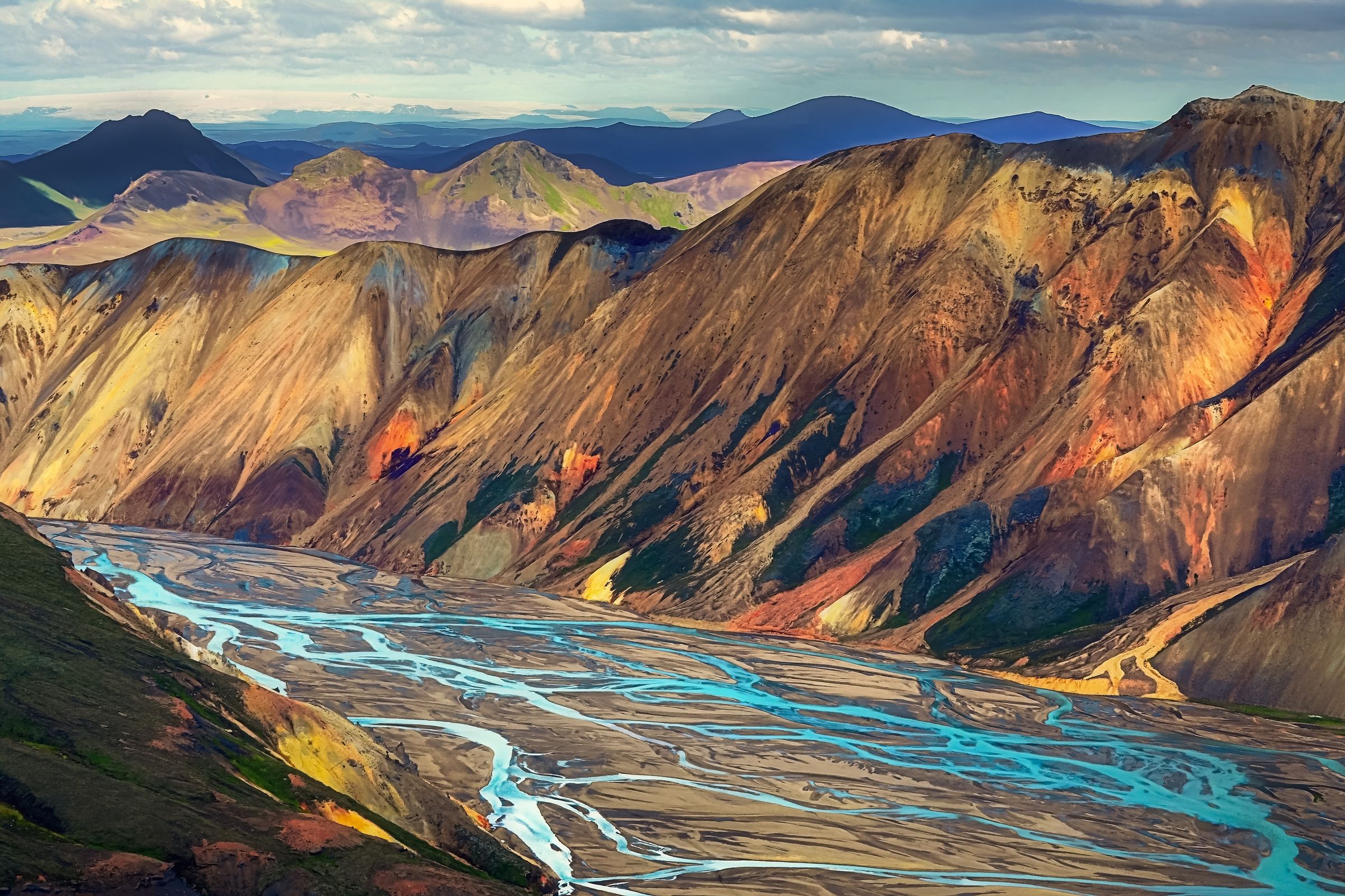
Landmannalaugar
This area is also part of Fjallabak Nature Reserve but deserves its own section. Landmannalaugar is famous for the rhyolite mountains that come in different colors: pink, red, yellow, green, and even blue. This is due to the mineral deposits created by the geothermal activity happening underneath the surface. This same energy has created the Landmannalaugar baths. They are just by the parking area and it’s an amazing and free chance to discover Icelandic bathing culture. Several trails depart from the parking area. Short ones, like the Laugahraun lava field loop, offer easy walks with panoramic views, while the Brennisteinsalda hike leads through sulfur springs.
Þórsmörk
Southwest of Mælifell, Þórsmörk is a green valley named after the Norse god Thor (it can also be spelled Thorsmörk). If you’re coming from Reykjavik through the route we described before, you’ll pass just by it. This area exhibits great contrasts, much like the one seen at Mælifell, with green patches surrounded by volcanic black sand. You can take on fantastic hiking trails, such as the Fimmvörðuháls pass, which crosses between the Eyjafjallajökull and Mýrdalsjökull glaciers, revealing waterfalls and volcanic craters. The valley's rivers and gorges provide marvelous spots for picnics.

Katla
Katla, one of Iceland's most active volcanoes, hides beneath the Mýrdalsjökull glacier, just south of Mælifell. As it’s covered by an ice cap, its eruptions cause glacial floods that have a significant impact in the surrounding landscapes. But don’t worry, it last erupted back in 1918, and local authorities monitor it closely. In the southern part, close to the coast, you can visit Katla Ice Cave, but it’s an activity for the colder months. The area around it includes black sand beaches on the coast, formed by volcanic debris.

Laugavegur Trail
This is, by far, the most famous and iconic hiking route in all of Iceland. It’s a 55-kilometer (34 miles) trail that connects Landmannalaugar and Þórsmörk, passing close to Mælifell. It usually takes 3 to 4 days to complete, and there are mountain huts and camping areas along the way to spend the night. Expect steaming vents, colorful hills, and glacier views during your trek.

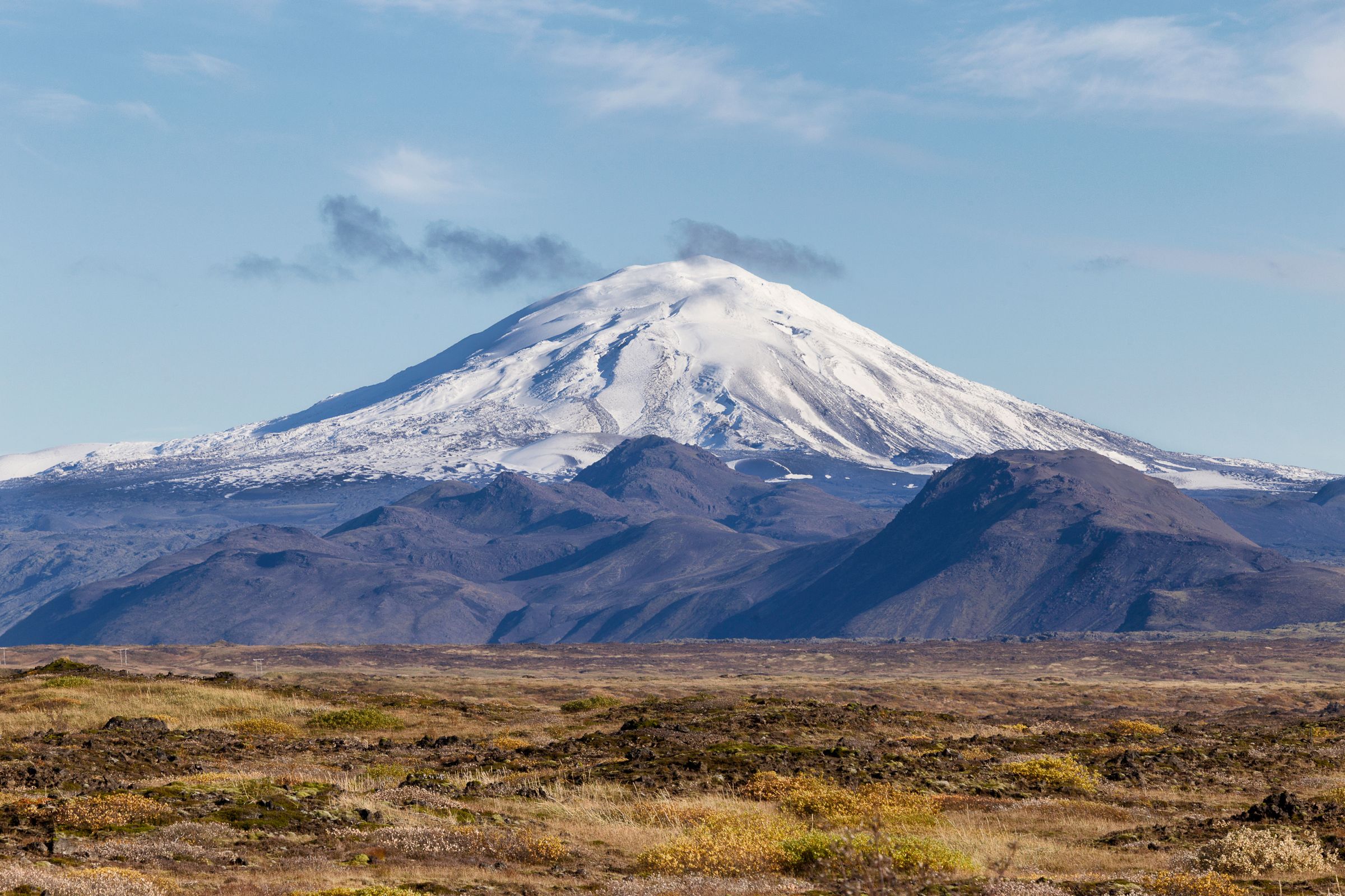
Hekla Volcano
Hekla, dubbed the "Gateway to Hell" in medieval times, rises northwest of Mælifell and is one of Iceland's most active volcanoes. Standing 1,491 meters (4,892 feet), it has erupted over 20 times in recorded history. That is, since the first settlers arrived in Iceland, back in the 9th century. The most recent eruptions took place in the year 2000.
The Weather at Mount Mælifell
In Iceland, the weather is a huge factor to consider when traveling to the country. In general, it’s quite unpredictable and is constantly changing, so you have to be prepared for all kinds of events. This is especially significant in the Highlands, as the elevation and geographical elements add an extra layer of variability to the already unstable conditions.
The only time of the year when Mount Mælifell is accessible is summer, between June and September. That’s mainly because the roads leading up there close the rest of the year because of the adverse weather.
Summer at Mount Mælifell brings mild conditions, with temperatures ranging from 5°C to 15°C (41°F to 59°F). Days are very long, with almost 24 hours of natural light by the end of June and beginning of July. It’s often sunny, but rain and wind can appear suddenly out of nowhere. Also, the high elevation can make the temperature feel lower than it is. In open areas, wind is almost a constant companion, and it can bring rain if it comes from the south.
By mid-September, some roads start to close, but there could still be chances to go to Mælifell if the weather is stable. The first days of snow can happen at higher elevations, and by October, it’s almost impossible to go there. Anyhow, as we mentioned earlier, always keep an eye on the weather forecast and the road conditions to make sure it’s safe to travel.

What to Pack to Visit Mount Mælifell
When heading to Mount Mælifell, pack thoughtfully for the remote and variable conditions. Here's a list of essentials:
- Waterproof jacket and pants: Essential for sudden rain and wind in the Highlands.
- Layered clothing: Base layers, fleece mid-layers, and a warm jacket to adapt to the temperature changes.
- Sturdy hiking boots: Waterproof with good grip. The terrain up there is quite uneven and it can be muddy if rain has hit.
- Hat, gloves, and scarf: Even in summer, chilly winds can bite.
- Sunglasses and sunscreen: The sun can be surprisingly strong, and the low temperatures can deceive us.
- Reusable water bottle: Stay hydrated; fill from clean streams if needed, the water is clean and drinkable.
- Snacks and packed lunch: There are no shops or services around Mount Mælifell, so come prepared.
- Map and GPS device: The cell phone signal can be spotty or weak in the Highlands. This way, you’ll still find your way.
- Backpack with rain cover: For carrying your stuff on hikes.
- Swimsuit and towel: Even if it sounds strange, you might want to combine Mælifell with a visit to a hot spring nearby.
- Photo camera: This place looks like nothing else and is one of the most searched natural monuments by photographers. If not, a phone should do.

Travel Tips
- Plan your trip for July or August when roads are most reliable and moss is at its greenest.
- Rent a 4x4 with high clearance, as it’s forbidden to drive on F-roads with a conventional car. Think well about your insurance options.
- Fill up on gas in Hvolsvöllur or Vík before entering the Highlands. There are no stations in this region.
- Drive slowly and carefully on F-roads to avoid damage. If you have to cross a river, stop and assess its depth. Don’t cross unless you’re completely sure.
- Respect nature by staying on paths and packing out trash.
- Always prioritize weather checks over schedules.
Conclusion
Mount Mælifell is one of those sights that is impossible to forget for those who’ve seen it. It’s a monument sculpted by nature, a combination of raw natural forces that have gone delicate to create a unique place. Rent your car, plan your route, and enjoy one of the most beautiful places in Iceland.


